


Introduction
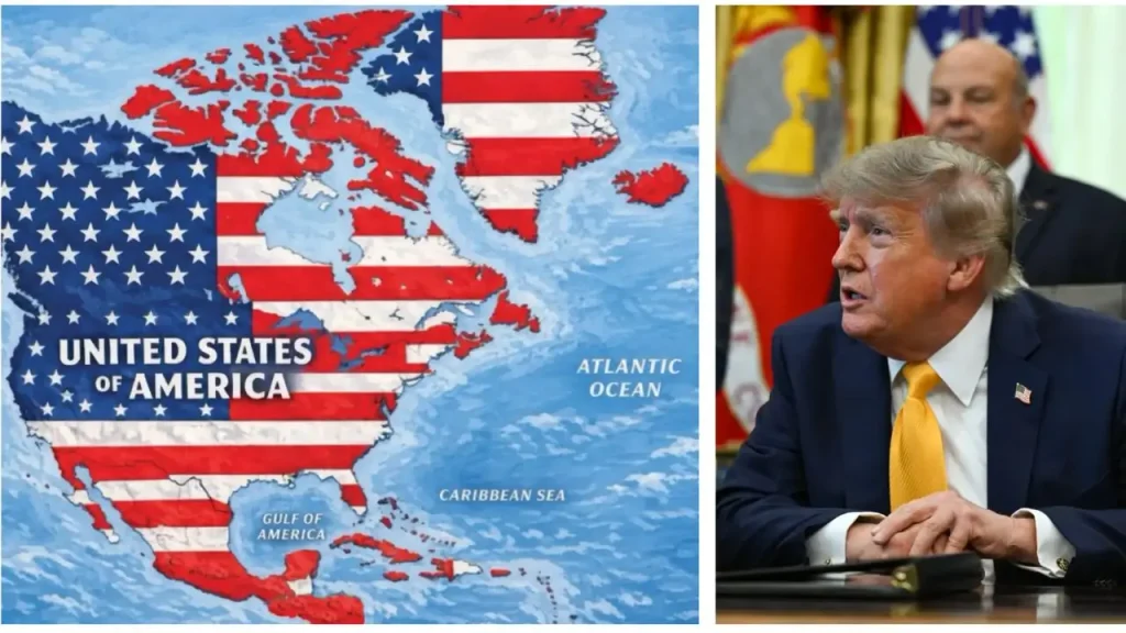
The Iceland reaction Trump map post controversy has quickly become more than an unusual social-media story. On September 7, 2026, U.S. President Donald Trump shared an image on Truth Social depicting a huge portion of North America, Greenland, Iceland, Mexico, Central America and the Caribbean under the colors of the American flag. The entire area was labeled “United States of America,” but Trump provided no explanation for what the image was intended to mean.
For Iceland, the reaction was immediate and unusually formal. Icelandic Foreign Minister Þorgerður Katrín Gunnarsdóttir summoned U.S. Ambassador Billy Long and conveyed that the post was “completely inappropriate.” The response is significant because Iceland and the United States have traditionally maintained a close security relationship. Iceland is a founding NATO member and has relied heavily on cooperation with Washington for its defense despite having no standing military of its own.
The controversy also arrives at a particularly sensitive moment. Trump has repeatedly spoken about Greenland, an autonomous territory within the Kingdom of Denmark, while his administration has also faced tensions with Canada. Iceland lies only about 300 kilometers from Greenland, meaning developments involving American ambitions in the Arctic are not distant theoretical issues for Reykjavik. The latest map therefore touched a much wider nerve: national sovereignty, Arctic security and the future of relations between the United States and its European partners.
1. What Did Trump’s Map Post Actually Show?
The image shared by Trump presented a dramatically expanded version of the United States. Canada, Greenland, Iceland, Mexico, much of Central America and the Caribbean were shown with the stars-and-stripes design, while the broader landmass was labeled “United States of America.” The post appeared on Trump’s Truth Social account without an accompanying explanation, policy statement or clear indication that it was intended as satire.
That lack of context became central to the controversy. A political cartoon or joke can be interpreted very differently when it is shared by a sitting U.S. president, particularly when it involves the territory of another sovereign country. Icelandic officials therefore did not treat the picture simply as an amusing internet post. They viewed its presentation as inappropriate because it appeared to place Iceland inside the borders of the United States.
The inclusion of Iceland was particularly striking because Trump’s earlier territorial comments had focused heavily on Greenland and, at times, Canada. Iceland had not been the primary subject of his expansion-related rhetoric. Its appearance in the new map therefore generated questions about whether the image represented a deliberate political message, an exaggerated joke, or simply another provocative social-media post.
Whatever the intention, the diplomatic consequences were real. Iceland’s Foreign Ministry confirmed that its ambassadorial meeting was used to communicate a clear objection. Reuters reported that the Icelandic government considered the post “completely inappropriate,” while other reporting described the reaction as a formal protest.
2. Why Iceland Took the Map So Seriously
At first glance, the episode might seem like a dispute over an internet graphic. But Iceland’s geography gives the story a much deeper dimension. The country sits in the North Atlantic between Europe and North America and occupies an important position for transatlantic military and maritime routes. Its location has made Iceland strategically valuable to the United States and NATO for decades.
Iceland became a NATO founding member in 1949 and has maintained a bilateral defense agreement with the United States dating to 1951. Although Iceland does not maintain a conventional military, its security arrangements have traditionally depended on NATO cooperation and its close relationship with Washington.
That history makes the symbolism of the map especially uncomfortable. Iceland’s relationship with the United States is based on cooperation between sovereign states. A picture suggesting that Iceland is already part of the United States cuts against that diplomatic framework, even if no formal American policy calls for Iceland’s annexation.
There is also a recent history behind Reykjavik’s sensitivity. Trump has repeatedly discussed the strategic importance of Greenland and his desire for greater American control there. Greenland is geographically close to Iceland, and developments surrounding Greenland have therefore attracted considerable attention in Reykjavik.
| Topic | Key Details |
|---|---|
| Main Keyword | Iceland reaction Trump map post |
| Person Involved | Donald Trump |
| Country Reacting | Iceland |
| What Happened | Trump shared a map depicting Iceland and several other territories under the U.S. flag |
| Platform | Truth Social |
| Iceland’s Response | Iceland summoned the U.S. ambassador |
| Icelandic Foreign Minister | Þorgerður Katrín Gunnarsdóttir |
| U.S. Ambassador to Iceland | Billy Long |
| Iceland’s Position | The map was described as completely inappropriate |
| Sovereignty Issue | Iceland is an independent and sovereign republic |
| NATO Connection | Iceland is a founding NATO member |
| Military Status | Iceland does not maintain a conventional standing military |
| U.S.-Iceland Relations | The two countries have longstanding security and defense cooperation |
| Greenland Connection | Trump’s interest in Greenland has increased sensitivity across the North Atlantic |
| Geographical Importance | Iceland occupies a strategically important position between North America and Europe |
| Main Concern | The symbolism of portraying Iceland as part of the United States |
| Broader Issue | Sovereignty, Arctic security and U.S. relations with European allies |
| Overall Significance | A social-media post created a diplomatic dispute between two longstanding partners |
The political atmosphere became even more complicated after Trump repeatedly referred to Iceland while discussing Greenland earlier in the year. U.S. Secretary of State Marco Rubio later acknowledged that Trump had mixed up the two countries, according to reporting on the latest dispute.
For Icelanders, another incident involving Iceland being placed inside an imagined American territory could therefore feel less like an isolated joke and more like part of a continuing pattern.
3. The Greenland Connection Behind the Controversy
The strongest background to the Iceland reaction Trump map post is Trump’s long-running interest in Greenland. Greenland is an autonomous territory within the Kingdom of Denmark and has its own government, while Denmark retains responsibility for areas including foreign and security policy.
Trump’s push for American control of Greenland has already caused serious disagreements with Denmark and generated repeated statements from Greenlandic and Danish officials rejecting the idea that Greenland should become American territory. The new map brought those tensions into a much broader picture by adding Iceland and other territories to the apparent U.S. footprint.
Danish Prime Minister Mette Frederiksen again emphasized that Greenland’s government and population have repeatedly said they do not want to become American. Her comments came as European Commission President Ursula von der Leyen visited Greenland and the European Union announced a €200 million investment package.
That timing matters. The map was not published in an empty political environment. It appeared while European governments were attempting to strengthen relationships in Greenland and reinforce European involvement in Arctic affairs.
For Iceland, the situation is particularly sensitive because of geography. Greenland and Iceland are close neighbors in the North Atlantic, and any major shift in the balance of power around Greenland could influence Iceland’s security environment, trade routes, military planning and diplomatic calculations.
The dispute also demonstrates how Arctic politics have changed. The region is no longer viewed merely as a remote zone of ice and scientific research. Arctic territories have growing strategic importance because of their location, natural resources, shipping possibilities and proximity to major military powers.
Iceland’s response therefore cannot be separated from the wider Arctic debate. A map that might look absurd on a computer screen can acquire very different significance when it appears against a background of repeated territorial statements by a major military power.
4. Iceland’s Political and Public Response
The Icelandic government’s decision to summon the American ambassador was the clearest official response to the post. Foreign Minister Þorgerður Katrín Gunnarsdóttir called in Ambassador Billy Long and made Iceland’s position known directly. The Foreign Ministry subsequently described the post as completely inappropriate.
The choice to summon an ambassador is meaningful. It is a diplomatic mechanism for expressing serious concern without automatically escalating a dispute into a broader confrontation. Iceland was able to make its objection unmistakable while preserving normal diplomatic channels with Washington.
The incident is also noteworthy because Ambassador Long had only formally taken up his post in Reykjavik recently. His tenure had already attracted attention after he made a remark earlier in the year suggesting Iceland could become the 52nd U.S. state and that he could serve as governor. He later apologized. The latest controversy consequently arrives after an earlier episode that had already made Icelandic public opinion more sensitive to comments about American control.
The public debate cannot be separated from Iceland’s broader discussion about Europe and security. Iceland recently held a referendum on whether to resume negotiations concerning European Union membership. Voters rejected the proposal on August 30, although the debate itself had unfolded partly against the backdrop of uncertainty surrounding U.S. policy toward Greenland and the wider North Atlantic.
This creates an interesting political paradox. Iceland has historically maintained strong links with the United States while remaining outside the European Union. Yet repeated American statements about neighboring territories can encourage Icelanders to reconsider how they balance relationships with Washington, Europe and other North Atlantic partners.
That does not mean Iceland is abandoning its relationship with the United States. Far from it. The country’s NATO membership and long-standing defense cooperation remain important. But diplomatic relationships can be close while still containing disagreements over sovereignty and political rhetoric.
5. What the Trump Map Could Mean for U.S.-Iceland Relations
The immediate dispute is unlikely by itself to overturn decades of cooperation between Iceland and the United States. Both countries have strong strategic reasons to maintain their relationship. Iceland occupies a valuable position in the North Atlantic, while Washington benefits from cooperation with a NATO ally positioned between North America and Europe.
However, repeated controversies can gradually change the political atmosphere. When leaders make comments that appear to question the sovereignty of neighboring countries, allied governments may begin preparing for a wider range of possibilities. Even if no territorial action follows, uncertainty can influence defense planning and diplomatic priorities.
For Iceland, the key issue is therefore less about whether the map represents an actual American plan to annex the country. There is no evidence from the post itself that it constitutes a formal policy announcement. Instead, the concern lies in what such imagery communicates about American attitudes toward sovereignty and territorial boundaries.
The episode also illustrates the unusual power of presidential social media. A traditional diplomatic statement passes through institutions and usually carries carefully selected language. A social-media image can be posted in seconds and seen around the world before diplomats have had an opportunity to interpret it.
That creates a difficult situation for allies. Officials have to decide whether a provocative image should be ignored, treated as humor, or answered formally. Iceland chose the third option because it believed the symbolism warranted a direct response.
The wider lesson extends beyond Iceland. Canada, Denmark and Greenland have all faced different forms of pressure or controversy involving American territorial rhetoric. The latest map placed several of those disputes into one image, making it a powerful symbol of the current debate over U.S. influence in the Western Hemisphere and Arctic region.
Sovereignty Remains the Central Issue
At the heart of the disagreement is a straightforward principle: Iceland is a sovereign state. It became an independent republic in 1944 and maintains its own government, institutions, territory and international relationships.
A political map may not change legal borders, but maps carry enormous symbolic weight. They show who governs a territory and where one country’s authority ends and another begins. When a map presented by a world leader redraws those boundaries, governments can reasonably question what message is being communicated.
That is why Iceland’s response was stronger than a casual dismissal. Reykjavik wanted to make clear that cooperation with Washington does not mean acceptance of imagery suggesting Iceland belongs to the United States.
Conclusion
The Iceland reaction Trump map post controversy is ultimately about much more than a strange image shared online. The map placed Iceland under the American flag alongside Canada, Greenland, Mexico, Central America and the Caribbean, creating a visual statement that Iceland’s government considered unacceptable. Reykjavik responded by summoning the U.S. ambassador and making its objection explicit.
The episode is especially significant because it comes amid continuing disputes over Greenland, strained U.S.-Canada relations and growing strategic competition in the Arctic. Iceland’s geographic position makes it particularly attentive to changes in the North Atlantic security environment.
For now, the incident does not amount to evidence of an American plan to annex Iceland. But it does demonstrate how quickly an apparently simple social-media post can become a diplomatic issue when questions of sovereignty, territorial integrity and national identity are involved.
Iceland and the United States remain important security partners. The challenge for both sides will be maintaining that relationship while navigating increasingly provocative political rhetoric. In the North Atlantic, where geography places allies unusually close to one another, even a map posted without an explanation can carry consequences far beyond the screen.
10 Frequently Asked Questions
1. What was the Trump map post about?
Donald Trump shared a map on Truth Social showing the United States, Canada, Greenland, Iceland, Mexico, Central America and the Caribbean covered by the American flag. The larger territory was labeled “United States of America,” and Trump did not provide an explanation with the image.
2. Why did Iceland react to Trump’s map?
Iceland objected because the image appeared to depict Iceland as part of the United States. Iceland’s Foreign Ministry considered the post inappropriate and summoned U.S. Ambassador Billy Long to communicate the government’s position directly.
3. Did Trump officially claim Iceland as U.S. territory?
The map itself did not constitute a formal territorial claim or official policy announcement. Trump posted the image without explanation. Iceland nevertheless treated the symbolism seriously because of the broader context surrounding U.S. territorial rhetoric.
4. What did Iceland’s foreign minister say about the post?
Foreign Minister Þorgerður Katrín Gunnarsdóttir summoned U.S. Ambassador Billy Long and communicated that the post was “completely inappropriate,” according to Icelandic authorities and international reporting.
5. Why is Greenland relevant to the Iceland controversy?
Trump has repeatedly expressed interest in acquiring or gaining control over Greenland, which is an autonomous territory within the Kingdom of Denmark. Greenland is geographically close to Iceland, so developments involving its sovereignty have direct strategic relevance to Reykjavik.
6. Is Iceland a U.S. military ally?
Yes. Iceland is a founding member of NATO and has a long-standing defense agreement with the United States. Iceland does not maintain a conventional standing military, making NATO cooperation and international defense arrangements particularly important to its security.
7. Does Iceland have its own military?
Iceland does not have a conventional standing military. Instead, it relies on NATO membership, its defense relationship with the United States and other security arrangements to protect its territory and national interests.
8. Has Trump confused Iceland with Greenland before?
Yes. During earlier discussions about Greenland, Trump repeatedly referred to Iceland, and U.S. Secretary of State Marco Rubio later acknowledged that Trump had mixed up the two countries. The earlier confusion added sensitivity to the latest map controversy.
9. Did Iceland recently consider closer ties with the European Union?
Yes. Iceland recently held a referendum concerning whether to resume negotiations over European Union membership. Voters rejected the proposal on August 30, 2026. The debate took place partly amid broader discussion about European security and changing U.S. policy in the North Atlantic.
10. Could the map damage U.S.-Iceland relations?
The post could create diplomatic friction, particularly if similar incidents continue, but it does not by itself end the long-standing U.S.-Iceland security relationship. Both countries have substantial strategic reasons to maintain cooperation through NATO and their established defense arrangements.
